Whitewater

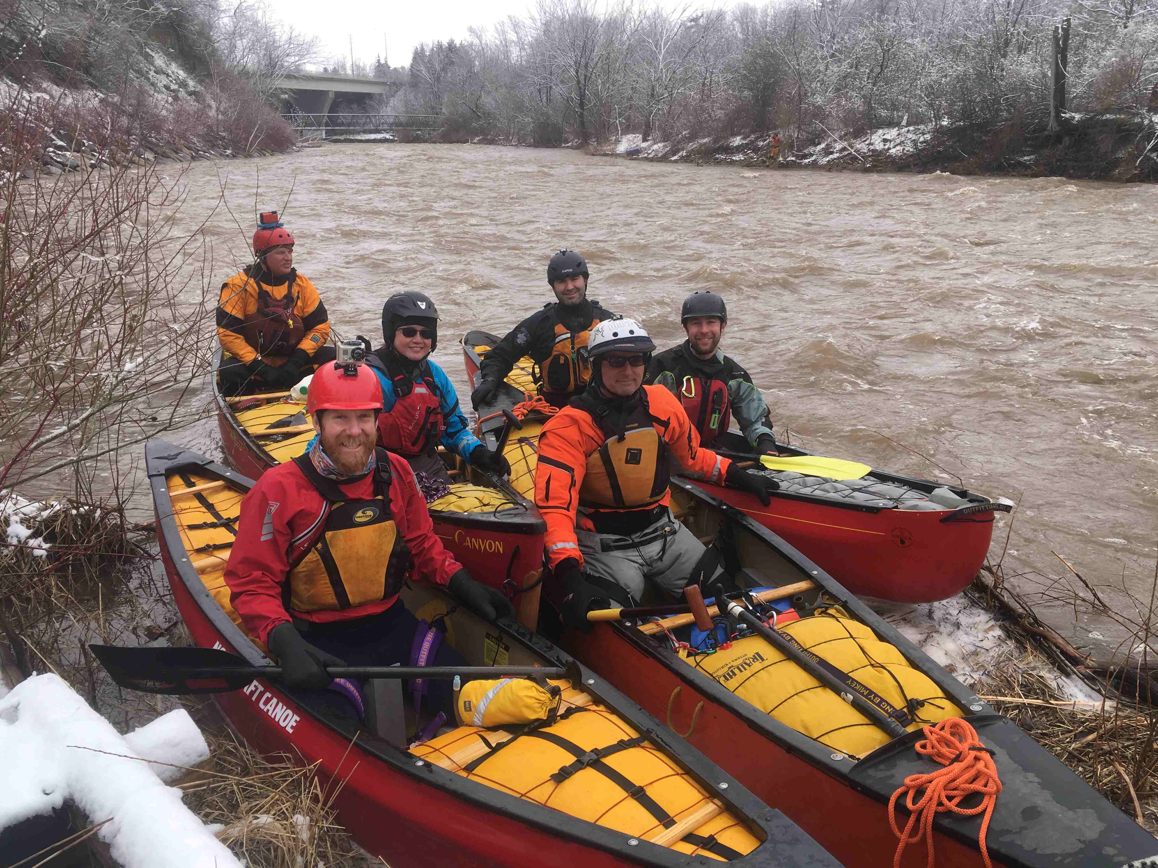
Bazin River, Quebec -- Looking for one more intermediate level whitewater paddler to complete a tandem canoe.

Outing Type → 

We are a group of 5 looking for one more paddler to do the Bazin River, in Quebec.

The Basics
Event Location

3 hours north east of Ottawa, on the Bazin River.

Date(s) & Time
Event Duration
7 in total: 5 on the water + 2 days travel
Difficulty Rating
Intermediate
Registration Cut Off
May 10
Participant Info
Who's Invited
Intermediate + Whitewater paddlers
Maximum Group Size
4 tandem boats
Minimum Group Size
2 tandem boats
Itinerary
Itinerary description

We will leave early on Sunday, May 12, and drive to the area of Mont Laurier, Quebec. Leaving early May 12 we will travel east to, and spend the night at 'Club Gatineau', on the Gatineau River. Monday morning we will be shuttled to Parent, Quebec, to begin our roughly 140 km paddle south (probably 5 days), back to the Club Gatineau.":
We will share the preparation of breakfasts, dinners, but be responsible for making our own lunches. All other expenses will be divided equally amongst the 6 paddlers. We will stay at 'the club' before and after the trip. We originally had 6 people but one dropped out. Please contact the organizer to discuss your interest in our trip.

Required Items to Bring

Dry Suit, Good paddle, PFT, your portion of the preserved meals for this trip, sleeping bag, foamy, good dry Tent etc.

Recommended Items to Bring

This will be an early spring paddle ... bring extra dry clothes, good warm sleeping bag, tent etc.

How to Get There
Event Directions

We will leave early Sunday May 12, arriving in the early evening. We will paddle about 140 km in 5 days, finish paddling on Saturday, May 18th. Likely we will drive back to Ontario May 19th.

Carpool Info

TBA - 3 cars traveling north and East, 1 canoe and 2 persons per car.

Other
Notes

You must be a reasonably good white water paddler with an intact and functioning dry suit. This river has lots of action ... We will paddle through most class I's, II's, and III's. Anything bigger than that we will portage.

Cancellation Policy
Please give notice as soon as possilbe!

Palmer Rapids July first weekend

Outing Type → 

An informal gathering at Palmer Rapids for WCA members.  Folks can camp at Jessups or Paddler's Co-op.  My kids and I will be at Paddlers and I booked 4 spots for WCA members if you want to mention this when booking.
I am thinking about paddle and play at Palmer Rapids Saturday, the Lower Madawaska run Sunday (Canada Day!) and some play and departure Monday.  We will show up Friday evening.
As we are just finished school and in the midst of a busy work schedule no further planning is being made.  If people want to organize a group meal or activities please forward thoughts on the spreadsheet that you will receive if you sign up.


The Basics
Event Location

Paddlers Co-op/Jessups

Date(s) & Time
Event Duration
2/4days
Difficulty Rating
Novice
Registration Cut Off
None
Participant Info
Who's Invited
Open
Maximum Group Size
None
Minimum Group Size
None
Itinerary
Itinerary description

Friday or Saturday arrival. Saturday play at Palmer Rapids, Sunday Lower Mad day trip. Sunday/Monday departure

Required Items to Bring

Absolutely safety gear is required! Helmets, pfds, floatation, throw ropes and bailer. Good river shoes, rash guard and sunscreen. Let’s not be careless and remember our safety as well as others as responsible members of the white water community.

Recommended Items to Bring

Good humour, camping necessities, ww friendly canoes or kayaks

How to Get There
Event Directions

Palmer Rapids, Ontario

Carpool Info

Check spreadsheet for possibilities

Other
Notes

Might have my pizza oven up there, we can discuss later on a group email. Remember to fill out waivers for the kids.

Kids or first timers Saugeen River paddle

Outing Type → 

Hi. 

Each year my family and I paddle from Walkerton to the first takeout.  It is an enjoyable afternoon paddle of 15km and an energetic 10 year old can solo it in a kayak.  We take time to swim and play about on few surf waves or catch crayfish and usually return to Walkerton for an icecream before heading home.

This is a sunny day paddle and will be canceled if rain or high winds threaten!  

The Basics
Event Location

Lobies Park, Walkerton

Date(s) & Time
Event Duration
4/5 hours
Difficulty Rating
Beginner
Registration Cut Off
May 31, 2024
Participant Info
Who's Invited
kids with guardians, first time paddlers
Maximum Group Size
10 boats
Minimum Group Size
my family
Itinerary
Itinerary description

We will meet at Lobie's Park in Walkerton (Access#5) for 10am. After making sure we have everything shuttle vehicles to Saugeen Access #6. We will paddle as a group, stopping at the bluffs to enjoy our packed lunches, some throw bag practice and surfing.
Afterwards, if people want to get in line for ice cream in Walkerton at the Brant Drive-In they are more than welcome.
This is a gentle stretch of river with some class one fun. It is important that we remain as a group to be safe.

Required Items to Bring

Life jackets, helmets if kayaking, bailers and painter, sun screen, drinking water, snacks, good humour, sun hat, foldable chair if you want, quick dry clothing etc...

Please contact me if you need to borrow a children's sized life jacket we have a few to share.

Recommended Items to Bring

As above

How to Get There
Event Directions

They will be forwarded to those who sign up.

Sunday April 21 MAD River (Whitewater) Creemore to Glencairn 90 min from Toronto

Outing Type → 

After a couple of years of not being available due to massive log jams, my favorite river, the MAD River (near Creemore Ont) , cleaned itself up in the rains of early April 2023, and a group of WCA members ran the fourteen kilometers of fast moving whitewater fun from Creemore to Glencairn (the river at that time of year rarely slows down)
I would like to do it again a bunch of times in the spring of 2024. This year I am put up two trips for April 13 and April 14 and they sold out but had to be cancelled due to high water, so I am offering it again the following weekend and two single one day trips. You choose the day, or do both. I may add more later in the spring at the last minute if river levels are ok.
Every person who registers for this trip is subject to review and acceptance by the trip organizer, which includes having each paddler submit a canoeing / river resume of training and experience on whitewater rivers. The trip organizer reserves the right to cancel the reservation of any paddler who does not comply with this request or refuses to answer follow up questions about their prior paddling experience. You will in turn be send a summary of my paddling background. The Mad River is MAD when it gets MAD (levels change quickly in spring / summer rain storms like April 9, 2024
Read this gauge:

https://wateroffice.ec.gc.ca/report/real_time_e.html?stn=02ED015&mode=Gr...

The water rose 2.5 times it’s volume in just 4 hours on April 9. Simply MAD ???? Come play with me. Can supply a tandem canoe if a team needs one.

Tandem Canoes get Priority for signup. For safety, the group requires at least two tandems for forward scout and rear sweep. I can bump up the canoe count from six if I get signups who did the river April 13 or April 14

The Basics
Event Location

Meeting Place - Riverside Dr and County Road 9 in Creemore Ontario

Date(s) & Time
Event Duration
one day (five to six hours on water)
Difficulty Rating
Advanced
Registration Cut Off
Thursday at noon (last minute can be done but please be reasonable)
Participant Info
Who's Invited
WCA members and friends of members
Maximum Group Size
6 boats
Minimum Group Size
2 boats
Itinerary
Itinerary description

Meet at Riverside Drive / County 9 in Creemore at 10am. Drop boats and gear. Shuttle as many cars as we can to Glencairn Conservation Area on Webster Road in Glencairn (parking fee applies ) . Lunch will be on the river shore at Carruthers Memorial Conservation Area (just upstream from where the MAD River flows under Airport Road) . From here the river slows down a bit until our take out at Glencairn Conservation Area.

Required Items to Bring

REQUIRED: Drysuit, PFD, helmet, close toe shoes (no flip flops) . Painters for both ends of the canoe. Also bring your Whitewater PIN kit - carabiners, pulleys, accessory cord, webbing and throw bag) , in case we wrap a canoe, and a good hand saw if you have in (in case we have to cut a canoe out of a sweeper)
Please bring canoes that can handle hitting a few rocks (not your fancy kevlar or carbon fiber boats please) . I would prefer no Pac boats (gunnels too low) If Pac boat is s is all you have, please contact me before booking
Other items needed: PFD. Drysuit or wetsuit, Helmet (highly recommended), Sweater or additional warm layer for lunch stop, lunch, water, close toed shoes (no flip flops) .

Recommended Items to Bring

Change of shoes and towel to throw on seat of car you will be shuttling in. You probably want your change of clothes in a drybag or waterproof barrel to bring on the river , so that the change to dry is not delayed at end of day..

How to Get There
Event Directions

From Barrie: Take County road 90 (Dunlop ST exit off hwy 400) to Angus. Turn right on County Road 10 (just after Yellow NO FRILLS building) . Continue on County Road 10 to County Road 9 (for New Lowell and Creemore). Drive through New Lowell, continue through Creemore to Riverside Drive. Riverside Drive is about 1.5 km past the Fire Station which will be on your left as you leave Creemore. Turn right on River side Drive to Put In, about half a kilometer.
From western Toronto, drive up hwy 410 to hwy 89, right on hwy 89 to Airport Road, left on Airport road, driver north and turn left at Cashtown Corners to Riverside Drive. The Creemore Fire Station is at 76F55 County Road 9 in Creemore Ontario, which one minute east of the Riverside Drive put in.

Carpool Info

Contact Organizer. He lives up north in Stayner, near the river, but he will help organize car pool

Other
Notes

SRT trained paddlers, bring your rescue kit, including favorite compact saw if you have one.
Subject to 36 hour cancellation / reschedule by the organizer if pre scouting or online flow meter shows flow rates that in the opinion of the organizer exceed safe paddling conditions. This NOT a river for beginners.

Cancellation Policy
Yes you could, but please be sure you can come, please don't cancel.

Saturday April 20 MAD River (Whitewater) Creemore to Glencairn 90 min from Toronto

Outing Type → 

After a couple of years of not being available due to massive log jams, my favorite river, the MAD River (near Creemore Ont) , cleaned itself up in the rains of early April 2023, and a group of WCA members ran the fourteen kilometers of fast moving whitewater fun from Creemore to Glencairn (the river at that time of year rarely slows down)

I would like to do it again a bunch of times in the spring of 2024. This year I am put up two trips for April 13 and April 14 and they sold out but had to be cancelled due to high water, so I am offering it again the following weekend and two single one day trips. You choose the day, or do both. I may add more later in the spring at the last minute if river levels are ok.

Every person who registers for this trip is subject to review and acceptance by the trip organizer, which includes having each paddler submit a canoeing / river resume of training and experience on whitewater rivers. The trip organizer reserves the right to cancel the reservation of any paddler who does not comply with this request or refuses to answer follow up questions about their prior paddling experience. You will in turn be send a summary of my paddling background. The Mad River is MAD when it gets MAD (levels change quickly in spring / summer rain storms like April 9, 2024
Read this gauge:

https://wateroffice.ec.gc.ca/report/real_time_e.html?stn=02ED015&mode=G…

The water rose 2.5 times it’s volume in just 4 hours on April 9. Simply MAD ???? Come play with me. Can supply a tandem canoe if a team needs one.

Tandem Canoes get Priority for signup. For safety, the group requires at least two tandems for forward scout and rear sweep. I can bump up the canoe count if I get signups who did the river April 13 or April 14

The Basics
Event Location

Meeting Place - Riverside Dr and County Road 9 in Creemore Ontario

Date(s) & Time
Event Duration
one day (five to six hours on water)
Difficulty Rating
Advanced
Registration Cut Off
Thursday at noon (last minute can be done but please be reasonable)
Participant Info
Who's Invited
WCA members and friends of members
Maximum Group Size
6 boats
Minimum Group Size
2 boats
Itinerary
Itinerary description

Meet at Riverside Drive / County 9 in Creemore at 10am. Drop boats and gear. Shuttle as many cars as we can to Glencairn Conservation Area on Webster Road in Glencairn (parking fee applies ) . Lunch will be on the river shore at Carruthers Memorial Conservation Area (just upstream from where the MAD River flows under Airport Road) . From here the river slows down a bit until our take out at Glencairn Conservation Area.

Required Items to Bring

REQUIRED: Drysuit, PFD, helmet, close toe shoes (no flip flops) . Painters for both ends of the canoe. Also bring your Whitewater PIN kit - carabiners, pulleys, accessory cord, webbing and throw bag) , in case we wrap a canoe, and a good hand saw if you have in (in case we have to cut a canoe out of a sweeper)
Please bring canoes that can handle hitting a few rocks (not your fancy kevlar or carbon fiber boats please) . I would prefer no Pac boats (gunnels too low) If Pac boat is s is all you have, please contact me before booking
Other items needed: PFD. Drysuit or wetsuit, Helmet (highly recommended), Sweater or additional warm layer for lunch stop, lunch, water, close toed shoes (no flip flops) .

Recommended Items to Bring

Change of shoes and towel to throw on seat of car you will be shuttling in. You probably want your change of clothes in a drybag or waterproof barrel to bring on the river , so that the change to dry is not delayed at end of day..

How to Get There
Event Directions

rom Barrie: Take County road 90 (Dunlop ST exit off hwy 400) to Angus. Turn right on County Road 10 (just after Yellow NO FRILLS building) . Continue on County Road 10 to County Road 9 (for New Lowell and Creemore). Drive through New Lowell, continue through Creemore to Riverside Drive. Riverside Drive is about 1.5 km past the Fire Station which will be on your left as you leave Creemore. Turn right on River side Drive to Put In, about half a kilometer.
From western Toronto, drive up hwy 410 to hwy 89, right on hwy 89 to Airport Road, left on Airport road, driver north and turn left at Cashtown Corners to Riverside Drive. The Creemore Fire Station is at 76F55 County Road 9 in Creemore Ontario, which one minute east of the Riverside Drive put in.

Carpool Info

Contact Organizer. He lives up north in Stayner, near the river, but he will help organize car pool

Other
Notes

SRT trained paddlers, bring your rescue kit, including favorite compact saw if you have one.
Subject to 36 hour cancellation / reschedule by the organizer if pre scouting or online flow meter shows flow rates that in the opinion of the organizer exceed safe paddling conditions. This NOT a river for beginners.

Cancellation Policy
es you could, but please be sure you can come, please don't cancel.

Saugeen River Run - TEST

Outing Type → 

This is part two of the Southern Ontario spring river runs.  Due to low levels we have been paddling the main sections of the Maitland and Saugeen.  These are friendly beginner/novice runs with the consideration of colder weather and water twmperatures.
We had comfortable accommodations at Camp Kintail for the Friday and Saturday evenings along with two breakfasts and Saturday supper for $115/person.  Please note, we are in dorm-like cabins or yurts; if you want privacy, bring a tent.
----------------------------------------------------
TESTING PURPOSE #13
 

The Basics
Event Location

To Be Determined

Date(s) & Time
Event Duration
Weekend
Difficulty Rating
Novice
Registration Cut Off
April 1st
Participant Info
Who's Invited
Paddlers
Maximum Group Size
30
Minimum Group Size
2
Itinerary
Itinerary description

Day 1 will either be Ayton to Hanover or Hanover to Walkerton.

Day 2 will be Walkerton to take out #7.

More or less 20km/day.

Please note if we get rain we might choose a more technical paddle if the group is comfortable with that!

Required Items to Bring

Cold water gear, safety equipment, lunches and snacks, Royalex canoe and good humour!

Recommended Items to Bring

TEST

How to Get There
Event Directions

To be given in future communications.

Saugeen River Run

Outing Type → 

This is part two of the Southern Ontario spring river runs.  Due to low levels we have been paddling the main sections of the Maitland and Saugeen.  These are friendly beginner/novice runs with the consideration of colder weather and water twmperatures.

We had comfortable accommodations at Camp Kintail for the Friday and Saturday evenings along with two breakfasts and Saturday supper for $115/person.  Please note, we are in dorm-like cabins or yurts; if you want privacy, bring a tent.

-------------------------------------------

TESTING#1

The Basics
Event Location

To Be Determined

Date(s) & Time
Event Duration
Weekend
Difficulty Rating
Novice
Registration Cut Off
April 1st
Participant Info
Who's Invited
Paddlers
Maximum Group Size
30
Minimum Group Size
2
Itinerary
Itinerary description

Day 1 will either be Ayton to Hanover or Hanover to Walkerton.

Day 2 will be Walkerton to take out #7.

More or less 20km/day.

Please note if we get rain we might choose a more technical paddle if the group is comfortable with that!

Required Items to Bring

Cold water gear, safety equipment, lunches and snacks, Royalex canoe and good humour!

How to Get There
Event Directions

To be given in future communications.

Lower Credit River

Outing Type → 

Join me on this classic early spring favourite of Toronto area paddlers. We’ll catch the Credit in Streetsville and run down to the mouth at Port Credit.

The river is a delightful continuous Class 1 to 2 with lots big bouncy wave trains and play spots.There are loads of opportunities to practice easy ferries and eddy turns as we work our way down the river. However, downed trees over the winter can create sweepers, and participants need to be able to manoeuvre a canoe in moving water to avoid them.

As well, the water will be cold. You need solid basic moving water skills. A full wetsuit or a drysuit is required to participate (no exceptions). Boats should have air bags in them.

We'll have lunch on the river at a park near Dundas Street, so bring something to eat. We usually finish the trip around 3 PM.

Water levels; March 27, 24 the water level is 4.7m.  Predicting by March 29 the water level will be ~4.60m. .  I did the river in 2021 at 4.55m level and it was ok.

If you are looking for a canoe partner or canoe to sit in, let me know, and I will try and coordinate connected people with canoes with people looking for a canoe.  Send me an email or call me.


The Basics
Event Location

Lower Credit River, Streetsville to Port Credit

Date(s) & Time
Event Duration
1 day
Difficulty Rating
Intermediate
Registration Cut Off
3/29/2024 at 8 am
Participant Info
Who's Invited
Solo and tandom whitewater canoes
Maximum Group Size
12 boats
Minimum Group Size
2 boats
Itinerary
Itinerary description

We meet at the put-in at 9:30 am in Streetsville N43.5796, W79.7064

https://maps.app.goo.gl/1HNC1QJoBWWrMbmCA

Lunch on the river at Erindale Park N43.5485, W79.6553

https://maps.app.goo.gl/z7dwMFGtTpLHemTS8

Takeout at Port Credit N43.5507, W79.5879

https://maps.app.goo.gl/86SHcC1AkVmnza9A8

Required Items to Bring

Whitewater canoe or kayak. Wetsuit or drysuit. Airbags for canoe. Lunch/water

Recommended Items to Bring

For lunch, a thermos is recommended as weather can be cool.

Spare clothes in a dry bag, if you decide to swim some of the river.

How to Get There
Event Directions

See Googlemaps Links

Carpool Info

We will coordinate at Streetsville putin on Friday morning.

Other
Notes

None

Cancellation Policy
only sign up if you are 100% sure you will attend

Upper Salmon River, April 28

Outing Type → 

This is especially for those people paddling the Moira River, April 27, with Bill Ness. When finishing the Moira some of us will camp locally as we may as well make the most of being local to both rivers. Others are welcome to come just for the day.
Considering the lack of snow in the bush this winter we shall make a call on whether we can, in fact, paddle this river this year as the date approaches.
Normally this is a class II and III river so we are looking for people who have some experience. You must have a whitewater boat (plus a bailer) and you must have either a full dry suit or wet suit. The organizers of this trip will reserve the right to exclude you if you turn up unprepared. Please bring throw ropes if you have them.
Come prepared to have a good time, socialize, and be supportive of other people's experience.

The main intention for this trip is 'tandem practice' for those of us intending to undertake back country trips up north this summer. Solo paddlers will be welcomed too, should there be space in the group.

The Basics
Event Location

Upper Salmon River

Date(s) & Time
Event Duration
one day, 6 hours
Difficulty Rating
Intermediate
Registration Cut Off
Sat., April 27, 2024
Participant Info
Who's Invited
WCA members
Maximum Group Size
8 boats
Minimum Group Size
2 boats
Itinerary
Itinerary description

We will paddle the length of the river and attempt all rapids available. We will begin at 10 am and be finished by 4 pm.

If you are camping locally the night before, or staying in a motel, please let the organizer know.
Also please let the organizer know who you are paddling with.

Required Items to Bring

White water canoe, an extra paddle, bailers, throw ropes, PFD's.
A proper wet suit or dry suit is mandatory.

Recommended Items to Bring

Lunch, snacks, portable water?.

How to Get There
Event Directions

Put In: Gull Creek intersection with Arden Rd. (Hwy 15), east of Kaladar, Ontario. (44.590311, -76.997787)
Take Out: Woodcock's Mills Rd. intersection with Salmon River. (44.525543, -77.032063)

Carpool Info

Work this out on your own. A list of participants will be available a few weeks before.

Other
Notes

Contact the organizer if you have any questions.

East Branch Spanish River (FULL)

Outing Type → 

The Spanish River is a Canadian Heritage River, that is supposed to have a little bit of everything for everyone. The East Branch will start out with some flat water and some swifts between lakes. And then it will turn into more of a river with some class 1-2 whitewater sections. There are portages if any of the rapids want to be skipped.
The geography of the area is classic Canadian Shield and boreal forest. The campsites are located on a mix of rock and sand. The river flows in the usual drop-and-pool style of Ontario rivers.

I have room in my canoe for one more, plus other boats are welcome. A group of 3 canoes and 6 people would be ideal.

The Basics
Event Location

847 Agnew Lake Rd, Webbwood, ON P0P 2G0

Date(s) & Time
Event Duration
7 days
Difficulty Rating
Intermediate
Registration Cut Off
06/13/2024
Participant Info
Who's Invited
Anyone who would like to join, whitewater experience is preferred
Maximum Group Size
4 boats
Minimum Group Size
2 boats
Itinerary
Itinerary description

Day 1: Duke Lake to Ninth Lake 10 kms
Day 2: Ninth Lake to First Lake 20 kms
Day 3: First Lake to Athlone Rapids 20 kms
Day 4: Athlone Rapids to Cliff Rapids 25-30 kms
Day 5: Cliff Rapids to the Knuckle 25-30 km
Day 6: Knuckle to Reynolds Creek 16-21 kms (Including a short hike to check out the old growth trees
Day 7: Reynolds Creek to Agnew Lake Takeout 20 to 30 km.
Day 8: Back up day incase we get windbound on Agnew Lake the day before.

Required Items to Bring

Canoes that can handle whitewater. Lining rope, paddles, helmet, lifejacket. Food, Shelter.

Recommended Items to Bring

Clothing, Stove, Whatever you normally take on a trip

How to Get There
Event Directions

Put in Agnew Lake lodge into GPS and meet there for 9am. Might have to pay for parking. Once I know whose coming we can plan on if we drive to Duke Lake, or use an outfitter to go with us and drive our car(s) back. More information will follow as I would like to communicate with the group on the finer details once the group is determined.

Carpool Info

I'm coming from South Western Ontario if someone would like to join I have room for another canoe on my car, and 3 people.

Other
Notes

I have one map of the spanish river, it is always helpful for a group to have two maps.

Cancellation Policy
Let me know if you can't make it after signing up so we don't wait around for you